 |
| Puc |
nedjelja, 11. svibnja 2008.
Puch, Vosteni
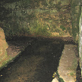
Puc or Puč is small water source near village Vošteni, Sveti Lovreč. It is cca 10 meters under ground surface. The water goes underground all to Lim bay. According to people stories it is discovered a long time ago by a cow who went down to drink. After that people build stone stairs and probably the water was used for drink, washing and cooking. Today the place is a little unarranged, there is no signs, so it is hard to find it if you dont know exactly where it is. Photos:
srijeda, 7. svibnja 2008.
Dvigrad
There are not many such beautiful and exciting dead towns located so near an urban area like Dvigrad in Istria. It was not destroyed by some military power, or devoured by fire; it was rather abandoned by its inhabitants to undergo its solitary death. Dvigrad is situated in Draga - a deep valley that stretches from Pazin to the sea, ending in a sea chanel - Lim. Dvigrad - as its name implies - consists of two towns. Today, only one town can be seen on the norhtern side of the valley, and it is in ruins. About the year 1630 the town was completely deserted. When the church of St. Sophia got abandoned in 1714, the town was left to its inexorable fate. We can enter Dvigrad through the city gate which has remained intact, and we reach the lower town which was protected by the first ring of the city wall. Following the way that Dvegrajci (as the inhabitants of Dvigrad are called in the Istrian memoirs) used to take for centuries, we arrive at the second gate, built in the second ring of the city wall. That's how the town was actually entered: from one gate to the another. We follow the way up to the third and the last gate, passing by an enormous guard tower situated in the southern part of town. Throught this gate we finally reach the centre of Dvigrad. On this highest position, as on a living rock, the early Christian church of St. Sophia was erected. It dominated the town due to its height, width and beauty. It had three naves, and in its centre, leaning against the pillars of the middle nave, a pulpit was constructed in the 13th and 14th centuries. The pulpit’s brim was decorated by beautiful reliefs. The most remarkable of them is the relief depicting St. Sophia holding one town in each hand. This is the symbol of Dvigrad. At the beginning of the 19th century the basilica collapsed, the roof fell in, and from that time on, this magnificent building has completely deteriorated. At the end, the question remains how much longer this deceased town will bear witness to the time, how much longer it will take before it has completely perished. Photos:
 |
| Dvigrad |
utorak, 6. svibnja 2008.
Pirates cave in Lim Bay
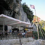
So called pirate's cave is supposedly associated with pirate Captain Morgan who traveled by his ship a long time ago trough Lim Bay. The cave is situated on the coast of Lim Bay (Limski Canal) - a wonderful region, densely covered with evergreen and deciduous trees, home to badgers, foxes, deer and wild boar. The Lim bay and valley is a peculiar geographic feature found near Rovinj and Vrsar on the western coast of Istria, Croatia, south of Porec. The name comes from the Latin limes for "limit", referring to the landform's position at the border of two Roman provinces (Dalmatia and Italia). The Lim valley (Limska draga or Limska dolina) is the 35 km long valley of the river Pazincica, which transforms into the Lim bay (Limski zaljev), a 10 kilometers long estuary. It is often called "Limski Fjord", or also "Lim fjord". Although the movie The Vikings starring Kirk Douglas was shot there in 1958, it is not a fjord but a ria, since it was not carved by a glacier but by the river eroding the ground on its way to the Adriatic Sea when the sea level was lower. Due to its narrow width it is also referred to as the Lim channel (Limski kanal). In the smal pirate's cave there is a bar where you can buy drinks and enyoj beutiful view:
 |
| Pirates cave |
ponedjeljak, 5. svibnja 2008.
Pajicka, Tinjan
Near the small villages Pajići, Travani and Jurići in Tinjan county is this beautiful water source named after village Pajići - tough is closer to village Jurići. The stone wall around it and stairs was build in year 1922 so the people from villages around can easy access it and use the water for drink and wash. Since 1997 when the last water infrastructure has come in all villages around, the Pajicka (Pajička, Pajićka) is today just a beautiful attraction for tourists and bikers who pass near by. It is not easy to find it, but if you follow the bike route "od lokve do lokve" signs you will eventualy pass near Pajicka. On my google map on the right is the exact location. Enyoj the pictures:
 |
| Pajicka |
subota, 3. svibnja 2008.
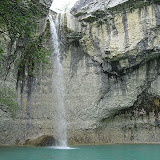
Sopot waterfall
The highest Istrian waterfall, Sopot, is located near village Floricici in central Istria. You can arrive by car to Floricici and the waterfall is just 5 minutes away by walk. Take the Gracisce-Pican-Potpican road, and after Pican in village Zajci turn left to Donji Kralji and Svici. Or you can choose to take St. Simun walking trail from Gracisce and trough village Zlepcari arrive to Sopot. The water falls 30 meters in small green lake. You can enjoy the beauty of water from the top where is a small old stone bridge, or you can go down to the lake by a little dangerus trail. The best time to visit Sopot is in winter, spring or autumn because of water quantity.
Photos and video:
Photos and video:
 |
| Sopot waterfall |
Pretplati se na:
Postovi (Atom)